Monday, October 25, 2010

A successful beginning: Recapping the Mankato Marathon


A few scattered thoughts on what was a memorable first marathon weekend in Mankato. I would have gotten around to this earlier, but a combination of work, icing and 'Inception' in the cheap seats conspired against it:

  • Hats off to the marathon organizers for setting up the pasta feed like they did. Rather than crowding everyone into one area for it (which would have been tough at the Verizon Center with Colorado College in town to play the Mavericks), they set it up at multiple restaurants all over town. Each restaurant also had it's own unique style of pasta on the menu. Not only does it help get local businesses involved with the marathon weekend, but it makes it possible to accommodate a large number of race participants (a number that will probably get bigger in the future, more on that late).
  • Local businesses seemed to take definite interest in the inaugural race. Aside from the pasta feed and numerous sponsors setting up stands at the expo, there was a healthy amount of coupons to be found in participants' race packets and goodie bags. This offers further encouragement that the marathon will have some definite staying power in the community. Also, it gives me an excuse to finally try out Number 4 for dinner.
  • Even though he didn't participate in the actual marathon (apparently due to a knee problem), getting Dick Beardsley to speak at the expo and sound off the start of the race was a nice touch. New races often take a year or two to catch on in a community, and getting a running legend like Beardsley (click here for a video of his famous Boston Marathon race) involved instantly gave the event credibility.
  • I can't say enough about how much I enjoyed the race course. Maybe I'm a little biased because I've biked/ran on the Red Jacket Trail more times than I can count, but I thought it was the ideal area to run the marathon through town without completely blocking off traffic. In my limited experience with racing (this was my third half marathon and there were people running Saturday whose have done more than 50), here's the checklist I have for what makes a good race course. Feel free to chime in with more suggestions:
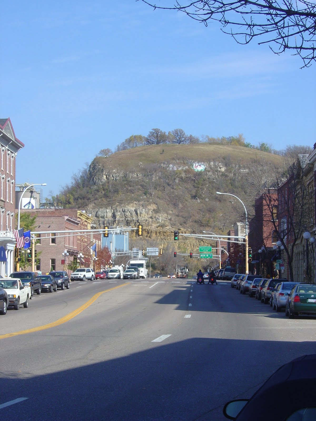
  1. Did the course showcase the city it was in? You bet it did. As my column in Sunday's paper indicated, the race almost served as a tour guide through Mankato. All that was missing was Minneopa Falls and Glen Taylor's mansion.
  2. Was the course clearly marked and easy to navigate? Very much so. There were twists and turns along the way, but each one was clearly marked with signs and volunteers were usually available to keep runners on track.
  3. Did it have ample spots for people to watch? It wasn't a constant wave of cheering spectators, but there was definitely a fair share of people lining the course throughout the race. The biggest crowds I remember seeing were at Sibley Park, Mount Kato and Front Street.
  4. Was it challenging without being overwhelming? I can't speak for the full marathon runners (I heard the hill for that course around Mile 4 was tough but manageable because it was early in the race), but surprisingly, the toughest part of the half marathon was actually a downhill slope. The hill along Hawthorn Road was a doozy to run down and probably led to plenty of runners nursing sore hips the next day.
  5. Were there plenty of water/aid stations? They had stations set up every 2 miles or so with EMT staff stationed throughout the course. The only thing I wish they would've had is a halfway point station with sport gel and energy shots.
  6. Did it have a picturesque spot for the finish line? Front Street was an excellent choice for the last few blocks of the race. Lots of history, vibrant downtown area and plenty of spots for spectators. It's hard to top finishing at the lift bridge and Canal Park in Duluth for Grandma's Marathon, but this was pretty darn good.
  • Even while attending the marathon forum last winter, I could tell that Mark Bongers and staff didn't intend for this to be a small-time event. They wanted to organize a premier race with the ability to grow in the future. If the inaugural race was any indication, they've most certainly done that. The 2,000-person registration filled early (with estimations that close to a 1,000 interested runners missed out) and according to the notebook in Sunday's marathon section of the Free Press, Bongers intends to bump up the registration to at least 4,000 next year, if not more. After running the race, I can say that the course can definitely accommodate more runners (aside from the start, it was never crowded). The only way I could see them needing to tweak the course is staggering the starts of the three races, and even that might be unnecessary.
  • Not that it has anything to do with the actual weekend festivities, but the fact that Bongers and his staff were so prompt about cleaning up after the marathon is just a further testament to how organized they were. There's hardly any evidence downtown that more than 2,000 runners raced through there on Saturday, and I'm sure Mankato residents and businesses appreciate that fact.
  • This is the first race I've ever done where I got to walk from the finish line back to my apartment. I could definitely get used to that, though in hindsight, a Bloody Mary at Pub500 immediately after the race wouldn't have been a bad idea either.
  • As far as how the race went for me, as the photo on the right (I'm the one rocking the Teenage Mutant Ninja Turtles t-shirt) would indicate, I'm hardly a paradigm for good running form. However, despite concerns about a recently-sore hip and side aches coming into play around Mile 10, I held up pretty well. I ran the entire race without stopping, passed the 1:35 pacer with a couple miles to go and finished with a time of 1:33:46. It's close to 5 minutes behind my half marathon time earlier this year, but considering how much less I trained for this one (averaged about 20-25 miles a week for 8 weeks), I was more than happy with it. Another plus: I'm not all that sore from it.

Thursday, October 21, 2010

Checking out the marathon course

Throwing tapering principles to the wind yesterday, I finally got around to checking out the Mankato 1/2 Marathon course for my last training. Call it pre-race nerves, but I figured it'd be nice to know what to expect on Saturday. Besides, one of the perks of running a race in your own town is having the ability to do so.

Mind you, I didn't run through the entire course. I bypassed the Sibley Park portion of the course to keep the run relatively short (about 9 1/2 miles). However, I later drove through the park to see if all the flood debris had been cleared off the running trail. From what I saw, it appears the National Guard and everyone else involved did a bang-up job cleaning alongside the river. So marathon participants won't have to worry about running through the mud.

Other observations about the course:

  • I'm going to keep my fingers crossed that the wind is either minimal or constantly at runner's backs on Saturday, because the first several miles of the course (most of the South Route Trail) offers little to no wind cove. Granted, I decided to do this run when there was a 20-30 mph wind advisory in Mankato, all of which was blowing right into my face for the first 5 miles. It's not likely to be THAT windy on Saturday (though the forecast does call for rain), but it could still make things tough for runners.
  • The main reason for doing this run was to see how my legs would handle the steep downhill area on the South Route Trail (Miles 4-5 for the 1/2 marathon, 17-18 for the full). When I first heard that the course included that hill, I was concerned that the steepness of it would cause a logjam of runners to topple over each other on their way down, not unlike siblings accidentally knocking each other down a crowded stairwell at dinnertime (not a regular occurrence in my family, but it happened). After all, I've never known the hill to be a barrel of fun to bike up. However, after running down the hill, I can say that it is definitely steep (and hard on the hips, as I'm still feeling it today), but it's nothing for runners to be worried about. The only concern is if rains and the course gets a little slick.
  • The Red Jacket portion of the trail (Miles 6-9 for the 1/2, 19-22 for the full) is a section of trail I've ran countless times in the past, so there was nothing new for me to learn there. It's a very scenic stretch with a good canopy of trees for most of it and, more importantly, no serious hills to climb.
  • I didn't run through Sibley Park for that training run, but I have ran through that area before. There's a slight hill coming out of the park along the river (roughly Mile 11 for the 1/2, 24 for the full), but beyond that, runners needn't fret about it. It's an easy park to run through and should also be a good viewing spot for spectators.
  • I'm actually kind of excited for the home stretch of the race. Front Street seems like an excellent place for runners to close in on the finish line. There's good viewing spots for family and friends, and it has a cavernous appeal to it for runners. If my legs can hold up until then, I'm sure the cheering of the crowd will help get the adrenaline pumping for the last few strides.

That's about all I can think of. Until Saturday, my plan is to stretch the legs out, ice the hip and get my fair share of pasta intake. The last training run was enough work.

Sunday, October 17, 2010

River valleys and bike trails: A 2-day trip to Red Wing

Some scattered thoughts about a 2-day bike trip I took to Red Wing last week:

  • The route I took can be broken down into four parts. I took the Sakatah Singing Hills Trail from Mankato to Faribault. From there, I hopped on Highway 3 and headed north to Northfield. Once in the town of Oles and Knights, I went west on Highway 19 to Cannon Falls (map between Faribault and Cannon Falls here). After that, it was a simple 20-mile jaunt on the Cannon Valley Trail into Red Wing. Collectively, it equated to being about 90-95 miles of biking one way and close to 200 miles both ways. A minuscule amount compared to what Eric and Christie Nelson pedaled (who are now back in Mankato after a 14,000-mile ride, congrats you two!), but a decent 2-day trip.
  • My reasons for taking the trip were simple. I had a couple days off in a row from work and was getting bored with the everyday rut I was in. It seemed like everyday revolved around either work or getting a good training run in; not my kind of routine. Aside from all that, I read about the Cannon Valley Trail in the bike trails book I rented from the library and wanted to see if I could make it there from the end of the Sakatah trail. Cannon Falls (the start point of the Cannon Valley Trail) is less than 30 miles from Faribault on back roads; turns out it was very feesible on a bike.
  • Since it was a 2-day trip, I had to pack a change of clothes and a tent on my bike somehow. I resorted to buying a $20 bar rack at Wal Mart and bungeed everything to it (see photo). I also packed a small bike repair kit on the front of my bike. The one hitch in this plan was that the rack wasn't designed for my bike and needed to be bungeed down to keep it from moving. Next time, I think I'll try someplace other than Wal Mart to do last-minute bike shopping.
  • I was initially going to use this trip as a way to explore the notion of connecting the Cannon Valley and Sakatah trails at some point. However, as the trip progressed, it turned into more of a juxtaposition of how much better shape the Cannon Valley Trail is in. See my column in Sunday's paper for further details.
  • Best part of the trip: Finding a random bar called Chuggers in downtown Cannon Falls to watch the Vikings-Jets game after setting up camp for the night. Good atmosphere, passionate fans, decent drink prices and an entertaining Monday night game. Not sure if I've ever head that many verbal barbs aimed at Brad Childress in one 3-hour stretch (which is saying something).
  • Worst part of the trip: The 16-mile stretch of road between Northfield and Cannon Falls. Rolling hills, no shoulder, busy traffic and curse-worthy swirling winds. Let's just say the beer at Chuggers tasted a whole heck of a lot better after that ordeal.
  • 2nd worst part of the trip: Paying $25 for a non-electric campsite to set my tent up for a night at the Cannon Falls Campground. I understand campsites need to make money, but charging the rate of a cheap hotel room for tent camping is a little ridiculous. I spent the rest of the trip wondering if I could have set up camp on the side of the road without being noticed.
  • Despite Red Wing being the destination of the trip, Northfield was probably the coolest town I visited. It's home to a very quaint (and bicycle friendly) downtown area by the Cannon River, complete with quirky shops and tasty local eateries. I looked around the mall there for awhile and, on the suggestion of locals and websites alike, ate at Basil's Pizza Place for dinner. GREAT pizza and very reasonable prices. St. Olaf and Carleton campuses were also fun to look at for awhile. Liberal arts colleges usually have some impressive old-fashioned architecture to admire, and these two were no exception. Considering Northfield is an easy 11-mile jaunt from the Sakatah trail, I might need to make that trip again sometime. The third photo on the right is a picture of Northfield from the viewpoint of the top floor of Larson Hall at St. Olaf. Beyond the buildings at St. Olaf, you can see Carleton College off in the distance on the left and can see the downtown area of Northfield as well.
  • I wish I would've had more time to explore Red Wing. I really only had about a 3-hour window to explore the town, and part of that was spent eating lunch at Liberty Restaurant downtown (recommended by locals; I wasn't a huge fan of it, too pricey). Red Wing apparently has some great hilltop vantage points from Memorial Park and Barns Bluff (pictured in the background in the first the photo, which is of Main Street in Red Wing). However, I didn't have the time to hike up to either of them. Instead, I looked at a few shops downtown, biked over the Mississippi River into Wisconsin, and checked out the riverfront park. Definitely fun, but there was more to see in that town.
  • As par for the course with my other bike adventures, this one was not without equipment problems on my two-wheeled companion. My rear-wheel brake lever actually detached from the handlebar between Northfield and Cannon Falls (see photo), making it impossible to use that brake for the rest of the trip (not the safest biking I've ever done). Additionally, the extra weight of my gear caused a rear-wheel spoke to break on the second day of biking. Thankfully, I was able to locate a bike shop in Cannon Falls (really more of an old-timey hardware store, really wish I would've got a picture of it) to fix my spoke and duct tape the brake lever back to my handlebars.
  • The trip was initially intended to be a 2-day adventure where I would leave late Monday morning and get back Wednesday around lunch. However, thanks to a combination of a head lamp and my legs getting second wind in Faribault, I managed to make it back into Mankato late Tuesday night. Collectively, Tuesday a 120-mile biking day, with the majority of the miles pedaled after 1 p.m. Not the best idea in retrospect, I felt like crap the next couple days.

Thursday, October 14, 2010

20 celebrity marathon runners that you wouldn't expect


A reader e-mailed this story to me the other day. It's a Nursing Schools blog entry on 20 surprising celebrities that have finished a marathon at one point or another. Considering we're 9 days away from Mankato's first-ever marathon, I figured readers would get a kick out of it.

The most surprising entries on the list (at least for me):

  • Will Farrell apparently ran Boston Marathon in 2003. No word yet on whether or not he did it while streaking. Even more shocking, he ran Boston more than an hour faster than Saved by the Bell star Mario Lopez, at least according to this website. When looking at the two of them, which would you think to be the better marathon runner?
  • Anthony Edwards (aka Goose from 'Top Gun') ran both the Chicago and New York City marathons. He should have talked Tom Cruise into running those with him. That way, he could have looked 7-feet tall in all the race photos.
  • Nightline anchor Ted Koppel ran the 1983 Marine Corps Marathon, apparently getting beat handily by World News anchor Charlie Gibson.
  • Sarah Palin clocked in at just under 4 hours in the 2005 Humpty's Marathon in Alaska. She's a fleet-footed Maverick.
  • Dana Carvey ran the 1972 Ocean to Bay Marathon in 3:04:21, easily the fastest time out of any celebrity listed. Considering his prowess on the drums (skip to the 1:30 mark), I kind of figured Carvey would be a decent athlete. Still, 3:04:21 is a darn good time for just about anybody.
After this year, you can add Jared from Subway to that list. As the saturation of Subway commercials have indicated, he's training for the New York City Marathon on November 7. We can only assume he'll be decked out in head-to-toe Subway attire.

Wednesday, October 13, 2010

Preserving history: The Red Jacket trestle bridge conundrum

Chalk up the Red Jacket trestle bridge as a casualty of the floods this fall.

Today's article in the Free Press confirms what many Red Jacket users have probably already guessed: The trail's historic trestle bridge across the Le Sueur River is to be dismantled due to extensive flood damage to the bridge's support pillar. The trail will be rerouted through a nearby park and will cross the river on the Highway 66 bridge, eventually linking back up with the trail on the other side of the Le Sueur. The detour is an already-existing part of the trail designed for anyone who might have had a fear of heights atop the trestle bridge.

This really shouldn't come as a surprise to anyone. The flood-ravaged pillar looks like a teetering Jenga tower and the relative age of the bridge (built initially in 1874) make it difficult to do repairs on. It's a shame to see such a picturesque part of the trail get torn down, but I saw the pillar up close; I wouldn't trust a mouse on that thing at this point.

Despite the glum news, there is a sliver lining for trail users to consider. The county is working tirelessly to get the bridge dismantled before winter, thus making it safe for cars and bikes alike to pass through on Highway 66 (the road currently passes under the bridge). Additionally, the bridge deck will be preserved with the hopes of building new support piers for it sometime next year. Even if a new bridge is not constructed right away. trail users will still be able to travel to Rapidan or visit the Rapidan Dam if they choose.

The best news to take from all of this is the sense of urgency being utilized by the county board and engineering offices. Clearly, the trail means a lot to them and they're working as hard as they can to repair it.

It won't get fixed overnight, but it's nice to know that city/county officials care as much about the trail regular users (like myself) do.

Thursday, October 7, 2010

The start of what could be one heck of a bike trail

It's amazing how you can live in one area for so long and still find something new about it on a regular basis.

At least that's the case for me when it comes to bike trails around my hometown of St. Cloud.

I grew up in the Central Minnesota town assuming that it wasn't anything special for cyclists. The most ambitious bike trip I recall making in my youth was when I attempted to bike across town to the dentist office when I was 10. I got lost, almost got run over by multiple cars and swore never to do that again. Even today, I dislike biking in the city itself. It lacks commuter bike trails and the town's haphazard traffic patterns it a nervous endeavor for cyclists.

However, as far as area recreation trails go, I would come to find out that you could do a lot worse.

While attending college at St. Cloud State University (yes Mankato readers, I was/am a Husky), I found out about the Lake Wobegon Bike Trail in the neighboring town of St. Joseph. The trail apparently went all the way to the town of Sauk Centre (roughly 35 miles west). which gave me the perfect excuse (at least in my mind) to borrow my step dad's undersized mountain bike and bike to my parent's cabin on Big Birch Lake (see map). Aside from knee and back pains that resulted, it was a great idea.

Last year, I found out that the Wobegon Trail links up with the Central Lakes Trail in Osakis, taking cyclists all the way west to Fergus Falls (about 105 miles total). This discovery led me to take a few days off from work to bike from my parent's house in Sartell to Fergus Falls and back. The end result of that trip: A flat tire, multiple bike malfunctions, God-awful sunburn, a column for the Free Press ... and a decision to sign up for RAGBRAI this past summer.

Last weekend, I made a similar discovery while visiting St. Cloud to attend a friend's wedding. With some time to kill on Sunday. I took my bike to an unfamiliar stretch of bike trail that went from the town of Holdingford to Highway 10 north of Royalton (roughly 14 miles). This stretch of trail is part of the partially-undeveloped Soo Line Bike Trail, which already connects to the Wobegon Trail in Holdingford and will eventually be paved all the way to southern shore of Mill Lacs Lake in Isle (see map). An 11-mile segment of the trail between Onamia and Isle is already paved.

When completed, the Soo Line/Wobegon/Central Lakes trails will combine to form roughly 160 miles of continuous paved trails, a hefty amount for even the most ambitious of cyclists.

But that wasn't the only cycling-related discovery I made. The Soo Line/Wobegon/Central Lakes trail system could in fact be the early workings of a massive trailway that a cyclist could only dream of.

A conversation with a local biker in Holdingford led to research into the following:

  • The Citizen's Committee in the town of Little Falls (roughly 25 miles north of St. Cloud) is currently working with MnDOT to extend the Paul Bunyan Bike Trail (which MPR recently reported being completed from Brainerd to Bemidji) through Camp Ripley down to Holdingford to link up with the Wobegon trail system. There isn't a target date yet for the completion of this project, but it is on the immediate agenda for both trail systems.
  • The Paul Bunyan Trail already links with the Blue Ox Trail in Bemidji, which travels all the way along Highway 71 up to International Falls. Currently, the Blue Ox Trail is mostly intended for snowmobile and ATV use, so it's mostly gravel and largely undeveloped. However, most related websites indicate that the Blue Ox will eventually be paved, combining with the Paul Bunyan Trail to form one of the longest rails-to-trails projects in the country -- roughly 210 miles.
  • The Glacial Lakes State Trail is currently a 22-mile stretch of paved trailway from Willmar to Hawick in West-Central Minnesota. However, plans are already in motion to extend the trail east to the town of Richmond (land has already been purchased to do so and maps have been drawn up), making it roughly 40 miles. Beyond that, the Minnesota DNR also has a long-term plan to eventually link the Glacial Lakes Trail to the Wobegon system (though the exact plans for this have yet to be defined). Also, check out the state trail system map on page 4 of the Glacial Lakes extension project. Looks like Mankato might the hub of a massive trail system in the future as well.
  • The Willard Munger Trail currently extends from Hinckley to West Duluth (roughly 70 miles) along Interstate 35. Considering the fact that the Soo Line's snowmobile/ATV trails already extends to Moose Lake (a town on the Munger Trail) and beyond, it's not far-fetched to believe the Soo Line and Munger bike trails might eventually be linked.
All in all, that's potentially seven trails covering nearly 500 miles of biking if they ever get linked together. It would go as far west as Fergus Falls, as far east as Duluth, as far north as International Falls and as far south as Willmar.

Take the information with a grain of salt, as DNR funding is pretty tight and the majority of these projects are still in the early stages of planning. But it's still something to to be excited about if you're cyclist looking for adventure.

Without being a great biking community itself, St. Cloud could wind up being a hub for one of the largest grouping of bike trails in the nation.
 

yaz